Prochain point : lat="49.1378" lon="1.718"

A remarkable location on the edge of the plateau
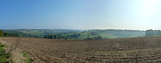
A human settlement overlooking hilly terrain
Omerville literally means "domain of Andemarus". The name is Germanic, "and" meaning wealth and "mar" meaning celebrated. Man adapted to the topography by building the village on top of the plateau. This defensive position and the circular pattern of the village streets going back to the Middle Ages, form an architectural ensemble of great interest. In medieval times the village was partly fortified and the layout of the city wall is still visible today. The dense construction of buildings was arranged around the church and manor of Mornay. On the Aubette de Magny valley side, the houses, dating from the eighteenth and nineteenth centuries, are set below, following the slope. The hillside drops gently down to the valley in a succession of plots where cereals are grown, interspersed with hedges and woodland.
The Epte valley, a Natura 2000 site
The Aubette de Magny passes through Hodent, Omerville, Ambleville and Bray-et-Lû before flowing into the Epte. The designated site, “Vallée de l’Epte francilienne et ses affluents » is a protected area under the European Natura 2000 “habitats, fauna and flora" directive. Around the slopes and sides of the plateaus there are calcareous grasslands, thermophile woodlands, valley floors and wetland areas. The fauna and flora are particularly rich: the wet grasslands harbour the Zannichellia palustris or Horned Pondweed; in the wet woodlands you can find Impatiens noli-tangere or Touch-me-not Balsam, and the wet meadows are home to the Southern Marsh Orchid or Leopard Marsh Orchid. The Southern Damselfly is found in the open wetlands of the valley floors, while the cicada species Cicadetta Montana lives in the limestone hills. Several remarkable species (European Bullhead, Lamprey and White-clawed crayfish) inhabit these waters.
An isolated fortified farm
La Louvière is a former commandery founded by the monks of St. Johns Order of Hospitallers in 1212 and converted into a farm in 1793. This vast farm is composed of several buildings, forming a closed quadrangle facing a central courtyard. The outside walls are windowless, giving the whole a fortified aspect. The house is impressive with its three floors built in rendered rubble stone, evenly distributed openings and four-sided slate-covered roof. A tower was added in the sixteenth century, but only a few vestiges remain on the ground, and these were included in the 1926 inventory of Historical Monuments.