Prochain point :
Ferme seigneuriale- Blamécourt
Prochain point : lat="49.1606" lon="1.80486"

Remarkable Location on the Plateau Edge
A landscape that slides into the valley
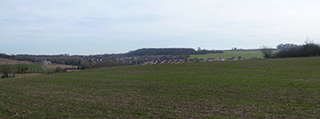
This high and remote viewpoint reveals a landscape that is typical of Vexin. Large parcels of cereal crops are peppered with copses as they slide down the plain to the foot of the hills. The horizon is interrupted by long wooded strips: to the east, the Garenne forest, and to the south, the Arthieul forest. The hamlet of Arthieul sits at the bottom of the Aubette valley.
The city and its four hamlets
Archaeological excavations have shown that Magny was founded close to an ancient rural settlement and Merovingian sites. Magny’s position on the Paris to Rouen road meant that it had an important economic role early on in its history. It was elevated to the status of a city in 1556 and became the administrative heart of the royal bailiwick. It then developed from being a very rural town in the Middle Ages into an important city marked by religion. Magny was populated by merchants and craftsmen under the Ancien Régime before undergoing major changes in the nineteenth century.
Today the city spreads out around a tightly-packed ancient centre that is defined by the surrounding boulevards. With its rural and medieval houses, the architecture reflects the town’s dynamism over the years. Four hamlets also belong to Magny. Arthieul, the former stronghold of the Guiry seigneurie, was independent until 1967, and is easy to spot with its school situated on the plateau overlooking the farms and country houses hidden on the valley floor. Blamécourt, which was originally a seigneurie, was part of the parish of Magny. The hamlet (which was autonomous until 1964) developed from the old seigniorial farm on the flanks of the hill. The hamlets of Vélannes-la-Ville and Vélannes-le-Bois in the upper valley of the Aubette derive their name from ‘villanae’, meaning ‘peasant lands.’ They formed a municipality from 1793 to 1863, the former being attached to Arthieul and the latter to Blamécourt.
Chaussée Jules César
The Roman road known as the Chaussée Jules César was almost certainly built in the first century. It formed part of a vast network of public highways based on a route linking Lyon (Lugdunum, capital of the Gauls) to the English Channel via Paris (Lutetia) and Rouen (Rotomagus). Archaeological excavations have revealed a neat and uniform construction. The road’s foundations consisted of an apron made of large blocks of stone laid flat, topped by several layers that provide the structure’s resilience. The road surface is made of crushed limestone bound with the lime or sand mortar. After crossing the cereal plateau, the Chaussée Jules César (which was six metres wide) enters Magny-en-Vexin via Arthieul. The 21 km between Arthieul and Puiseux-Pontoise were re-opened in 2000 by the Vexin Français Regional Park.