
Sentiers du Patrimoine ®
Genainville
Laisser le lavoir sur votre gauche et remonter la rue Serée. Après le virage, emprunter le premier chemin à gauche. Continuer toujours tout droit jusqu’à la D147 que vous prendrez à gauche. Le Vieux-Moulin se trouve à votre droite.
Vieux-moulin (fabrique de tire-bouchons)
Prochain point : lat="49.1339839999869" lon="1.745869"


The Genainville stream has its source between two narrow valleys, named the Vaux-de-la-Celle. It is joined on its left bank by the Préfonaine stream and swelled by the Aulnaie stream before flowing into the Aubette de Magny river. Other tributaries also run down from the hills, feeding fountains, watering troughs, ponds and lavoirs. Often, they are named after the street or locality where they emerge, for example: source de la rue Trognon, source de la Fontaine-aux-Pigeons or source de la rue des Rigauds. The Fontaine d’Argent was named for the silver mine that operated near Petit-Moulin for a number of years during the 18th century. Around ten fishing ponds have been created north and south of the village.
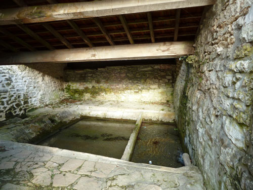
This lavoir, or wash-house, was built on the site of a water basin that can be seen on the 1819 land registry map. Prior to the construction of the lavoir, the water basin, measuring approximately 8 metres a side, may have already served as a lavoir, watering-trough or foot-bath. Today the lavoir is located at the foot of de la Séréestreet and, unusually for the region,is accessible via a ramp, rather than stairs. Closed on all sides, it is covered by two roofs sloping down inwards over the basin, so as to funnel in rain water and shelter washerwomen in times of bad weather.