Prochain point : lat="49.024207" lon="1.897934"

The gateway to the Vexin from the Seine Valley
An ancient settlement
Archaeological digs have uncovered a Merovingian necropolis (dating from fifth century until the mid-eighth century) on a limestone promontory overlooking the Montcient Valley. Two separate and independent burial grounds were uncovered containing a total of 259 graves. The grave goods found here include clothing accessories (clasps, brooches, belt buckles), jewellery, personal items (pouches containing needles, lighters, cut flints, arms) and crockery. These collective burial sites were abandoned sometime around the early eighth century, when cemeteries began to appear around the churches.
The first mention of a village dates from 1116, in the archives of the Saint-Martin de Pontoise Abbey. It was a Gallo-Roman hamlet alongside the Beauvais-Orléans Roman road. At the time, Gaillon was called Gaillum, which could also be written Wallonio (a Germanic term derived from the word waleo, meaning colony of foreigners. The current name dates from 1975, when the municipal council decided to add the suffix to the name of the commune so that people would no longer confuse it with its homonym in the Eure region.
A village nestling in a thalweg...
The commune is delimited to the south by the Montcient Valley and, to the north, it ascends towards the plateau. The village has grown up nestling in a markedly triangular thalweg. Along with the ancient settlement, set around the church and the château and which consisted of rural houses, farms and old mills, there are country houses and elegant holiday homes. Built in cut stone and rendered rubble-stone, the buildings feature grand façades punctuated with high porches, indicative of the village's agricultural activity. The mid-twentieth century brought a new feature to the landscape, when detached houses, set well back from the road, began dotting the hillside.
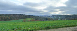
...between urbanisation and rurality
Large-scale cereal crops occupy the land on the plateau, while the hillsides are covered with pastures and wooded ground. The River Montcient flows through the bottom of the valley. Rising in Sailly, it flows into the Aubette at Meulan-en-Yvelines, just before its confluence with the Seine. Off in the distance, the landscape opens out, drawing the eye towards the Seine Valley and its heavily urbanised and industrialised sectors (Les Mureaux, Flins).