Informations directionnelles
Laisser la fontaine derrière et prendre la rue des martyrs à droite, puis la première à gauche, la rue de Chambly. Passer à côté du lavoir et prendre l’embranchement à gauche, rue Engenest. Ensuite prendre à gauche pour entrer dans le parc municipal. Longer les bâtiments pour arriver à l’étang afin d’y découvrir le panneau sur l’ancien château et son potager avec ses platanes.
Prochain point : lat="49.13884" lon="2.23708"
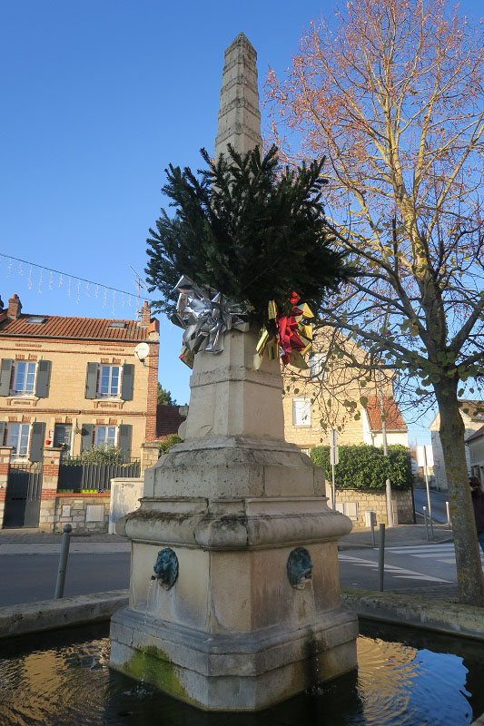
Place Corentin et Élie Quideau
A focal point
Homage to two heroes of the Resistance…
This square was a key junction for farmers that linked their fields and pastures on the banks of the Oise to the farms and fields on the hills. When the railway station opened in 1879, the population grew and density increased when the railway station opened in 1879. A year later in 1880, the town council decided to remodel the square, and it soon became the centre of the town. It took its name, Place des Tilleuls from the six lime trees planted there. The lime trees are gone and in 1948 the square was renamed Place Corentin et Elie Quideau in homage to local father and son, heroes of the Resistance.
…an obelisk fountain
Thanks to the keen eye of architect Pierre Colas, the 17th century obelisk was acquired from a salvage company in 1974. Although its provenance is not known with certainty, it may well have come from the royal estate in Versailles. It was converted into a fountain and now graces the square. The quadrangular basin with its canted angles is made from cut stone finished with a coping. The water gushes up in the centre of the basin through four taps with lions’ heads installed in the moulded base.