
Sentiers du Patrimoine ®
Ableiges
Poursuivre jusqu’à une croix sur la chaussée Jules-César. Poursuivre tout droit sur 1,2 km et prendre à gauche sur 800 mètres jusqu’à la route départementale 28. Suivre à droite le cheminement qui permet de passer au-dessus de la D14 pour rejoindre la Villeneuve-Saint-Martin. L’ancienne-école se situe sur la rue principale, rue François Vaudin, au numéro 2. L’Ancienne école de La Villeneuve-Saint-Martin.
Prochain point : Lat. 49.07815, Long. 2.09917
Ableiges and La Villeneuve-Saint-Martin were connected by the Longuesse path, visible on old maps. This path began at the Croix Blanche in the village, ran alongside the grounds of the former château, and crossed the plateau to the hamlet. Overgrown for some time, it was restored by the commune in 2024. In addition to reopening a pedestrian path between the village and the hamlet, the restoration also revealed the well-preserved boundary wall of the former château’s grounds. Just a few metres away, the Longuesse path intersects the Chaussée Jules-César, another ancient route. This Roman road, dating from the 1st century, connected Paris (Lutetia) to Harfleur (Caracotinum) via Rouen (Rotomagus). This route, gradually downgraded from the Middle Ages onwards, has been well preserved in certain areas, particularly in the French Vexin, where the road has been converted into a hiking trail.
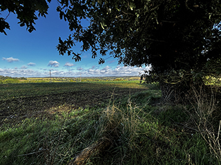
When looking at the landscape you can see how vast is the farm land and the river to Ableiges. These two elements played a major role in the village’s history. As it is often the case in the Vexin, agriculture was the main economic activity until the 20th century. In 1899, the main crops were cereals, potatoes, and sugar beet. Horses were used for fieldwork, and two farmers maintained a flock of 300 sheep. In addition, three water mills operated on the Viosne, used successively for milling, threshing, and woodworking, particularly by the Jacob company in the early 20th century. While these small traditional industries no longer exist, the village experienced significant population growth from 1975 onwards, due to its proximity to the new town of Cergy-Pontoise.